CARTERET COUNTY GOVERNMENT:
https://www.carteretcountync.gov/
COUNTY SEAT: Beaufort
FORMED: 1722
FORMED FROM: Craven
LAND AREA: 506.25 square miles
2020 POPULATION ESTIMATE: 67,686
White: 90.1%
Black/African American: 5.6%
American Indian: 0.6%
Asian: 1.3%
Pacific Islander: 0.2%
Two or more races: 2.1%
Hispanic/Latino: 4.4% (of any race)
From State & County QuickFacts, US Census Bureau, 2020.
CONGRESSIONAL DISTRICT: 3RD
BIOGRAPHIES FOR![]()
Carteret County
 WILDLIFE PROFILES FOR
Coastal Plain
GEOGRAPHIC INFORMATION
REGION: Coastal Plain
RIVER BASIN: Neuse, White Oak, Map
NEIGHBORING COUNTIES: Craven, Jones, Onslow, Pamlico

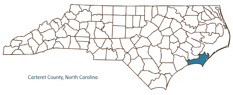
Carteret County, located in the Coastal Plain region of eastern North Carolina, was formed in 1722 from Craven County and was named for Lord Proprietor John Carteret. It is a largely coastal county that incorporates the southern end of the Outer Banks, including Cape Lookout. Early inhabitants of Carteret County included the Hatteras, Core, Neuse, and Tuscarora Indians, followed by French Huguenot, English, Scotch-Irish, and German settlers. The county seat is Beaufort, which was laid out by 1713 and incorporated in 1723, making it one of the state's oldest towns; it was originally called Fishtown but was renamed for the duke of Beaufort, Henry Somerset.
Carteret County is home to many of North Carolina's most popular and prosperous coastal communities and beaches, among them Morehead City (location of an official North Carolina state port), Emerald Isle, Indian Beach, Atlantic Beach, Cedar Point, Newport, and Harkers Island. The Beaufort area hosts marine research facilities associated with the University of North Carolina at Chapel Hill and Duke University. Tourism and recreational pursuits are principal elements of the county's economic life. The county also raises agricultural products such as corn, soybeans, tobacco, wheat, hay, potatoes, cotton, vegetables, poultry, and beef cattle. Manufactured goods produced in Carteret County are fish meal, concrete products, clothing, roofing products, and jewelry.
The Cape Lookout Lighthouse, erected in 1859 and now part of the Cape Lookout National Seashore, and Fort Macon State Park are two of Carteret County's important historic landmarks. A small wild horse population exists on Shackleford Banks, just south of Harkers Island. A North Carolina Maritime Museum and the Carteret County Historical Society, which operates a historical park in Beaufort. Among popular annual events and festivals in Carteret County are the summertime outdoor drama Worthy Is the Lamb (Swansboro), the Beaufort Old Homes Tour, the Emerald Isle St. Patrick's Day Festival, and the North Carolina Seafood Festival. The population of Carteret County was estimated to be 62,000 in 2004.
Annotated history of Carteret County's formation:
For an annotated history of the county's formation, with the laws affecting the county, boundary lines and changes, and other origin information, visit these references in The Formation of the North Carolina Counties (Corbitt, 2000), available online at North Carolina Digital Collections (note, there may be additional items of interest for the county not listed here):
County formation history: https://digital.ncdcr.gov/Documents/Detail/the-formation-of-the-north-ca...
Index entry for the county: https://digital.ncdcr.gov/Documents/Detail/the-formation-of-the-north-ca...
References:
Pat Dala Davis and Kathleen Hill Hamilton, eds., The Heritage of Carteret County, North Carolina (2 vols., 1982-84).
Additional resources:
Corbitt, David Leroy. 2000. The formation of the North Carolina counties, 1663-1943. https://digital.ncdcr.gov/Documents/Detail/the-formation-of-the-north-carolina-counties-1663-1943/3692099?item=4553233 (accessed June 20, 2017).
Carteret County Government: https://www.carteretcountync.gov/
Carteret County Chamber of Commerce: https://carteretchamber.org
DigitalNC, Carteret County: https://www.digitalnc.org/counties/carteret-county/
North Carolina Digital Collections (explore by place, time period, format): https://digital.ncdcr.gov
Image credits:
Rudersdorf, Amy. 2010. "NC County Maps." Government & Heritage Library, State Library of North Carolina.
1 January 2006 | Mazzocchi, Jay
