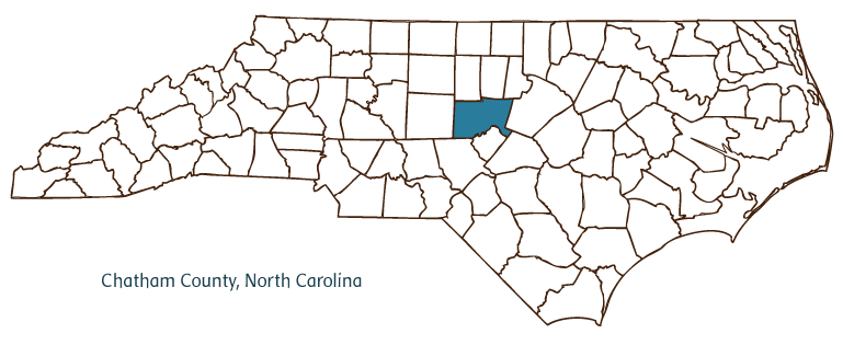
CHATHAM COUNTY GOVERNMENT:
https://www.chathamcountync.gov/
COUNTY SEAT: Pittsboro
FORMED: 1771
FORMED FROM: Orange
LAND AREA: 682.19 square miles
2020 POPULATION ESTIMATE: 76,285
White: 82.2%
Black/African American: 12.4%
American Indian: 1.2%
Asian: 2.2%
Pacific Islander: 0.1%
Two or more races: 1.9%
Hispanic/Latino: 12.1% (of any race)
From State & County QuickFacts, US Census Bureau, 2020.
CONGRESSIONAL DISTRICT: 6TH
BIOGRAPHIES FOR![]()
Chatham County
 WILDLIFE PROFILES FOR
Piedmont region
GEOGRAPHIC INFORMATION
REGION: Piedmont
RIVER BASIN: Cape Fear, Map
NEIGHBORING COUNTIES: Alamance, Durham, Harnett, Lee, Moore, Orange, Randolph, Wake

Chatham County, located in the Piedmont region of North Carolina, was formed from Orange County in 1771 in response to troubles stemming from the War of the Regulation. The county was named for William Pitt, earl of Chatham, who defended American rights in the British Parliament. Early inhabitants of Chatham County included Iroquoian and Siouan Indians, who were followed by Scottish, English, and German settlers. The county seat is Pittsboro-also named for William Pitt-which was incorporated in 1778 as Chatham but renamed Pittsboro in 1787. Other communities in Chatham County include Goldston, Siler City, Bennett, Brickhaven, Silk Hope, Moncure, Bynum, and Mount Vernon Springs. Physical features of the county include B. Everett Jordan Lake, a sprawling reservoir popular as a recreation area, and the Cape Fear, Deep, Haw, Rocky, and New Hope Rivers.
On the western edge of the booming Triangle area that includes Raleigh, Durham, Chapel Hill and environs, Chatham County is growing at a rapid rate. Nonetheless it still raises many agricultural products, including swine, tobacco, corn, soybeans, hay, poultry, and beef cattle. Manufactured products from the county include textiles, yarns, fabrics, furniture, and lumber. Sandstone, shale, coal, and iron are mined in the county.
Chatham County's historic landmarks include the Green Womack House (ca. 1819), the Pittsboro Masonic Lodge (ca. 1840), and the London Cottage (1861). The Devil's Tramping Ground, a mysterious and legendary 40-foot circular path in which no vegetation will grow, is located in Chatham County near Siler City. The Carnivore Preservation Trust is a sanctuary for unique endangered species located in Pittsboro and open to the public by appointment. The county's cultural institutions include the Chatham Theatre Guild and the Siler City Arts Council. Popular annual events and festivals include the Silk Hope Old Fashion Farm Days, Deep River Crescent Celebration, and Siler City Chicken Festival. In 2004 the population of Chatham County was estimated to be 55,000.
Annotated history of Chatham County's formation:
For an annotated history of the county's formation, with the laws affecting the county, boundary lines and changes, and other origin information, visit these references in The Formation of the North Carolina Counties (Corbitt, 2000), available online at North Carolina Digital Collections (note, there may be additional items of interest for the county not listed here):
County formation history: https://digital.ncdcr.gov/Documents/Detail/the-formation-of-the-north-ca...
Index entry for the county: https://digital.ncdcr.gov/Documents/Detail/the-formation-of-the-north-ca...
Additional resources:
Corbitt, David Leroy. 2000. The formation of the North Carolina counties, 1663-1943. https://digital.ncdcr.gov/Documents/Detail/the-formation-of-the-north-carolina-counties-1663-1943/3692099?item=4553233 (accessed June 20, 2017).
Chatham County Government: https://www.chathamcountync.gov/
Chatham County Chamber of Commerce: https://www.chathamchambernc.org/
DigitalNC, Chatham County: https://www.digitalnc.org/counties/chatham-county/
North Carolina Digital Collections (explore by place, time period, format): https://digital.ncdcr.gov
Image credits:
Rudersdorf, Amy. 2010. "NC County Maps." Government & Heritage Library, State Library of North Carolina.
1 January 2006 | Mazzocchi, Jay
