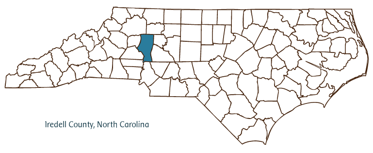
IREDELL COUNTY GOVERNMENT:
https://www.iredellcountync.gov/
COUNTY SEAT: Statesville
FORMED: 1788
FORMED FROM: Rowan
LAND AREA: 573.83 square miles
2020 POPULATION ESTIMATE: 186,693
White: 82.3%
Black/African American: 12.3%
American Indian: 0.5%
Asian: 2.8%
Pacific Islander: 0.1%
Two or more races: 2.1%
Hispanic/Latino: 8.0% (of any race)
From State & County QuickFacts, US Census Bureau, 2020.
CONGRESSIONAL DISTRICT: 10TH, 13TH
BIOGRAPHIES FOR![]()
Iredell County
 WILDLIFE PROFILES FOR
Piedmont region
GEOGRAPHIC INFORMATION
REGION: Piedmont
RIVER BASIN: Yadkin-Pee Dee, Catawba, Map
NEIGHBORING COUNTIES: Alexander, Cabarrus, Catawba, Davie, Lincoln, Mecklenburg, Rowan, Wilkes, Yadkin

Iredell County, located in North Carolina's Piedmont region, was formed by the division of Rowan County in 1788. The area was originally inhabited by Cherokee and Catawba Indians. It was named for James Iredell, North Carolina attorney general during the Revolution and delegate to the U.S. Constitutional Convention who was later appointed to the U.S. Supreme Court by President George Washington. Iredell County communities include Statesville (established as the county seat in 1789), Harmony, Love Valley, Mooresville, Troutman, Union Grove, Turnersburg, Mount Mourne, and Barium Springs. Lake Norman, the largest man-made lake in the state in terms of surface area, has 520 miles of shoreline within Iredell County.
Scotch-Irish and German immigrants seeking good soil, game, and proximity to freshwater had settled the area of modern-day Iredell County by 1753. Fort Dobbs (named after Governor Arthur Dobbs) was erected as a defense facility during the French and Indian War (1754-63). Today it is a North Carolina State Historic Site. The arrival of the Western North Carolina Railroad in 1858, soon followed by the Atlantic, Tennessee, and Ohio Railroad, marked the beginning of a long period of growth that continued through the first half of the twentieth century. Industries producing tobacco, liquor, and herbs (Statesville's Wallace Herbarium was one of the largest such facilities in the world during the late nineteenth and early twentieth centuries) were later supplemented by the production of livestock, dairy products, and breeder chickens, of which the county remains a leading producer. Iredell County hosts a number of recreational and cultural events, including the Ole Time Fiddler's and Bluegrass Festival in Union Grove and the National Balloon Rally in Troutman. The North Carolina Auto Racing Hall of Fame in Mooresville (known as "Race City USA") and Love Valley's western-themed campgrounds also attract numerous visitors. The population of Iredell County was estimated to be 136,000 in 2004.
Annotated history of Iredell County's formation:
For an annotated history of the county's formation, with the laws affecting the county, boundary lines and changes, and other origin information, visit these references in The Formation of the North Carolina Counties (Corbitt, 2000), available online at North Carolina Digital Collections (note, there may be additional items of interest for the county not listed here):
County formation history: https://digital.ncdcr.gov/Documents/Detail/the-formation-of-the-north-ca...
Index entry for the county: https://digital.ncdcr.gov/Documents/Detail/the-formation-of-the-north-ca...
References:
Genealogical Society of Iredell County, The Heritage of Iredell County, vols. 1 and 2 (1980, 2000).
Additional resources:
Corbitt, David Leroy. 2000. The formation of the North Carolina counties, 1663-1943. https://digital.ncdcr.gov/Documents/Detail/the-formation-of-the-north-carolina-counties-1663-1943/3692099?item=4553233 (accessed June 20, 2017).
Iredell County Government: https://www.iredellcountync.gov/
Greater Statesville Chamber of Commerce: https://www.statesvillechamber.org/
Mooreseville-South Iredell Chamber of Commerce: https://www.mooresvillenc.org/
DigitalNC, Iredell County: https://www.digitalnc.org/counties/iredell-county/
North Carolina Digital Collections (explore by place, time period, format): https://digital.ncdcr.gov
Image credits:
Rudersdorf, Amy. 2010. "NC County Maps." Government & Heritage Library, State Library of North Carolina.
1 January 2006 | Vocci, Robert Blair
